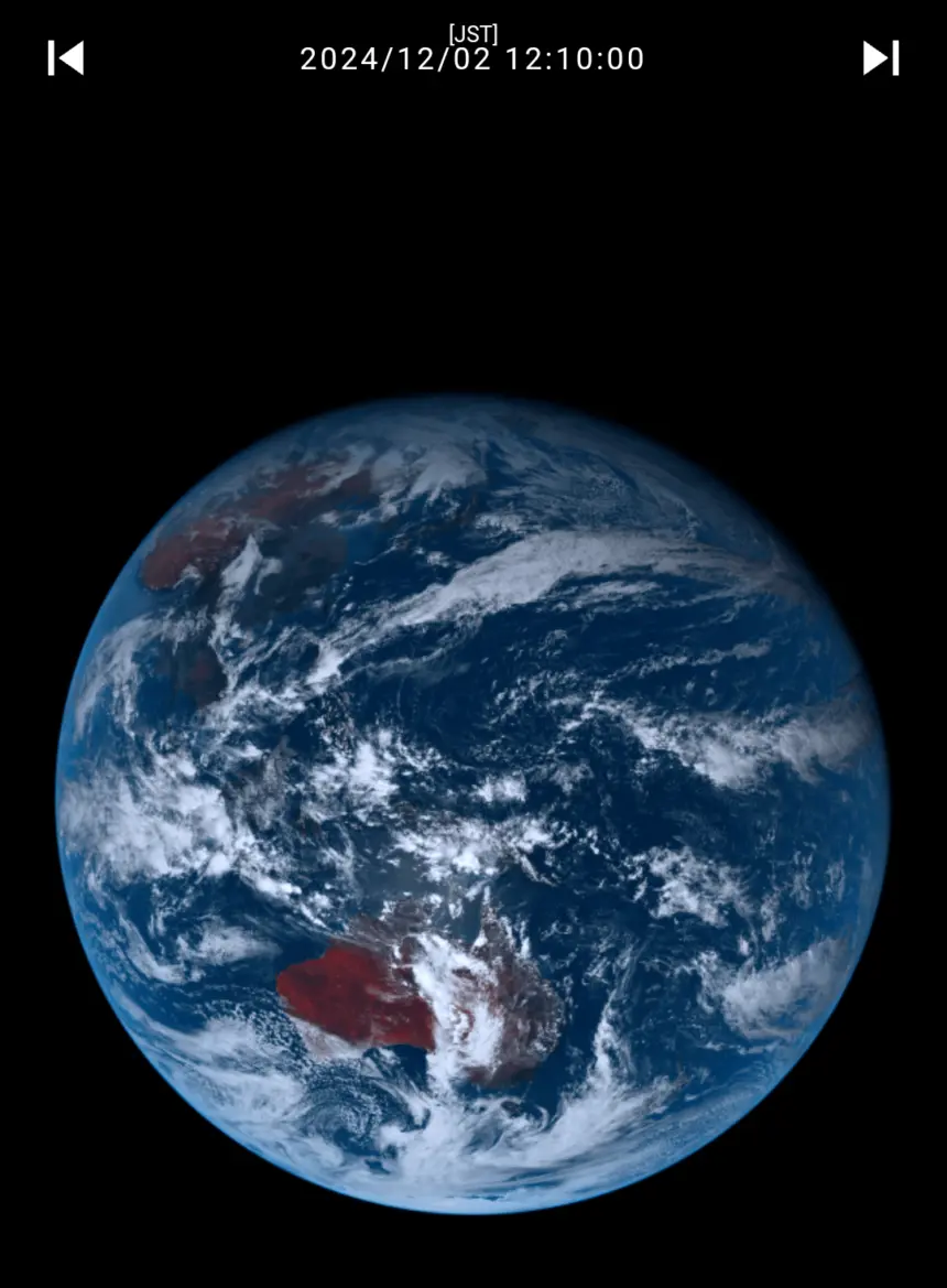
It’s geostationary, so you always get the same view of the planet.
Giant_leaps
3 months ago
To those who are wondering Australia is red because it is the entrance to hell and is covered with infernal flames.
Somerandom1922
3 months ago
To be clear, Australia is red, but not that red. The images from this satellite have what amounts to colour grading. The satellite operators make decisions about how they want to represent the specific wavelengths captured by the satellite which can make certain things look very different from how they do to our eyes.
Here’s the first photo taken by that exact same satellite for reference.
Cute-Organization844
3 months ago
Flat earthers will still deny the earth is round
Schlunzer
3 months ago
for everyone wondering: Australia is Red because of all the iron in the dust.
If you look closley you can see that China is red, too. However, this is not because of any iron in the dust but because of all the people who are members of the CCCP which is, as we all know, red.
Thank you for reading my shitpost.
RocketPuppyYT
3 months ago
Aight, who the fuck is playing plague inc?
LeeCloud27
3 months ago
Why is Australia red?
_fabiotis_
3 months ago
Hey, I’m in this photo!
Phil_Jarsen
3 months ago
Australia is red due to it being fucking hot at the moment. Had a shit day at work due to it
Nastix24
3 months ago
For those who don’t know, himawari means sunflower. It’s a very sweet name for a satellite.
biscute2077
3 months ago
Ong is that Caelid 💀
SnooHedgehogs8765
3 months ago
Can confirm. Absolutely dumped rain here in South Australia
ArtichokeFar6601
3 months ago
r/mapswithoutNZ
And before anyone gets upset, it’s a joke because NZ is covered by clouds.
This is a stitched together image as they all are. Do the research plus NASA and NOAA have always explained this before. No one has been able to get a full image of the earth due to lack of distance and equipment processing methods. Don’t be gullible.
Himawari 9, like other meteorological satellites, creates a full Earth image by taking multiple scans of the planet in “strips” using its Advanced Himawari Imager (AHI), essentially stitching together these scans of data (not photos) but rather multiple forms of data is then interpreted into images to form a complete picture of the Earth’s surface.
Himawari 9. It took over 2022. [https://en.wikipedia.org/wiki/Himawari_9](https://en.wikipedia.org/wiki/Himawari_9)
Real-time site is: [https://himawari9.nict.go.jp/](https://himawari9.nict.go.jp/) (or [https://himawari8.nict.go.jp/](https://himawari8.nict.go.jp/) )
It’s geostationary, so you always get the same view of the planet.
To those who are wondering Australia is red because it is the entrance to hell and is covered with infernal flames.
To be clear, Australia is red, but not that red. The images from this satellite have what amounts to colour grading. The satellite operators make decisions about how they want to represent the specific wavelengths captured by the satellite which can make certain things look very different from how they do to our eyes.
Here’s the first photo taken by that exact same satellite for reference.
Flat earthers will still deny the earth is round
for everyone wondering: Australia is Red because of all the iron in the dust.
If you look closley you can see that China is red, too. However, this is not because of any iron in the dust but because of all the people who are members of the CCCP which is, as we all know, red.
Thank you for reading my shitpost.
Aight, who the fuck is playing plague inc?
Why is Australia red?
Hey, I’m in this photo!
Australia is red due to it being fucking hot at the moment. Had a shit day at work due to it
For those who don’t know, himawari means sunflower. It’s a very sweet name for a satellite.
Ong is that Caelid 💀
Can confirm. Absolutely dumped rain here in South Australia
r/mapswithoutNZ
And before anyone gets upset, it’s a joke because NZ is covered by clouds.
[r/mapswithouttasmania](https://www.reddit.com/r/mapswithouttasmania)
/s
What is the red?
This is a stitched together image as they all are. Do the research plus NASA and NOAA have always explained this before. No one has been able to get a full image of the earth due to lack of distance and equipment processing methods. Don’t be gullible.
Himawari 9, like other meteorological satellites, creates a full Earth image by taking multiple scans of the planet in “strips” using its Advanced Himawari Imager (AHI), essentially stitching together these scans of data (not photos) but rather multiple forms of data is then interpreted into images to form a complete picture of the Earth’s surface.
1 of many links:
https://www.nesdis.noaa.gov/news/transforming-energy-imagery-how-satellite-data-becomes-stunning-views-of-earth#:~:text=Rather%20than%20capture%20an%20instant,scene%20that%20ABI%20can%20see)
Looks fresh
Seems about right. It’s been cloudy/raining here in parts of Indonesia
Classic NZ lol
Is there one of Europe?
Man clouds are really really huge like they’re the size of continents
the earth is so beautiful… i love my big blue marble
Caelid
it’s red so even aliens knows they should not go there
Australia is red?
god damn it, Malenia Blade of Miquella, not again.
I had 12 mls of that rain
Ok now post the other 143 pics
r/mapswithoutNZ but now in photographic form!
You’ve got red on you
Oh I’m in this one!